Add your fields faster, directly from the single application
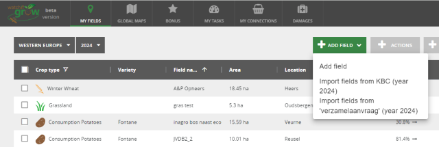
Via the Single application, you can make mandatory declarations and apply the Flemish Government for support measures for your fields. Would you like to load all your fields, from the Single application into WatchITgrow, in just one click? Be our guest to do so, from June 1, 2024!
- Go to the data sharing platform DjustConnect. There you give permission to share your field data from the Single application with WatchITgrow.
- Next, you add your CBE (Crossroads Bank for Enterprises) number in WatchITgrow. To do this, click on the link displayed upon logging in or go directly to your profile settings. You only need to do this once. This way, both databases are now connected via your CBE number.
- From now on, you can import your fields quickly and efficiently, avoiding double work!
Registering the condition of a field before sowing
Even before the start of the season, you can start monitoring fields in WatchITgrow. From now on, you can also add data about the condition of a field before sowing or planting: is the soil suitable for cultivation, what is the condition of the seedbed, is there a lot of weed present, and perhaps herbicide application is still needed?
Are you a crop advisor and are your growers also active in WatchITgrow? Is your company active with multiple individuals in a wide region? Then certainly share your fields in WatchITgrow, add your observations and any necessary actions, and everyone involved is immediately informed!
This functionality could be added thanks to the Flaxsense 2.0 project, financed by VLAIO and the flax sector.
Make optimal use of your soil scan data
From a soil scan, coupled with soil analyses, you can learn a lot about the differences in soil properties such as pH, organic carbon, and electrical conductivity (EC) within your field. You can use this information to take targeted actions to optimize soil quality at every location within the field.
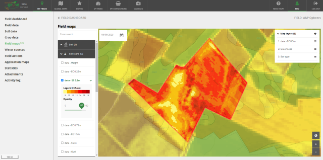
Have you had a soil scan of your field done? Then be sure to request, in addition to the soil scan report, the original soil scan data. You can add these shape-files (shp) or CSV-files as 'Attachments' in WatchITgrow. Then, in the 'Field Maps' section, you can view and compare the EC, elevation, pH, or other information derived from the soil scan with satellite images (greenness) or yield potential maps of your field. This allows you to immediately see the impact of differences in soil properties on crop growth and yield.
Conversely, by looking at the yield potential maps, you can also determine which fields have the greatest variations and for which fields it is definitely worthwhile to order a soil scan to investigate the cause of the variations.
If you wish to tailor fertilization or irrigation to different zones within your field, you can now also create application maps based on the soil scan. Of course, it is still possible to use the current greenness or yield potential map as a basis for your application map.
Project in the spotlight
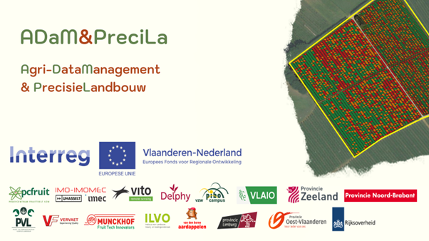
With the support of Interreg Flanders-Netherlands and the European Union, the ADaM & PreciLa project aims to bring improved Agri-DataManagement (ADaM), technical innovations, and practical demonstrations of Precision Agriculture (PreciLa) to growers in Flanders and the Netherlands. Of course, the WatchITgrow platform will also be utilized in this endeavor.
Thanks to ADaM & PreciLa and the integration with DjustConnect, we can not only retrieve field data from the Single application, but for sugar beet fields harvested with a Vervaet harvester, we can now also automatically import and display yield maps in WatchITgrow. If the beets are harvested by a contractor, no problem, we link the location data of the harvester to your field in the Single application and show you the yield map in WatchITgrow! You can also still view yield maps of AVR potato harvesters in WatchITgrow.
Importing soil scan data and creating application maps based on the soil scan could also be realized thanks to ADaM & PreciLa.
For more information about the ADaM & PreciLa project, click here (only in Dutch).
KBC Broad Weather Insurance
Growers who have the broad weather insurance for their crops with KBC can once again report any damage incurred this year in WatchITgrow. Thanks to our collaboration with DjustConnect, we automatically retrieve your insured fields from the Single application.
To report damage, go to your field in WatchITgrow and fill out the damage form. You can even indicate the exact location of the damage in the field or upload photos. Moreover, you can immediately check if your damage is eligible for compensation. Once completed you can submit the form via WatchITgrow to your KBC Insurance agent, who will then continue to handle your case.
For more information about the KBC Broad Weather Insurance, click here (only in Dutch).
What else to expect soon?
- The module for creating application maps will be further expanded! Starting from June, thanks to the integration with MAPEO, VITO's automatic image processing platform, you will be able to create application maps based on drone imagery.
- Do you operate your agricultural or horticultural business according to one of more agro-ecological principles? Soon, you'll be able to register this in WatchITgrow!
Additionally, we will add valuable information about the environment surrounding your agricultural fields, allowing you to view features such as small landscape elements, water bodies, and habitat maps in WatchITgrow.
- Finally, we are currently working on optimizing the tablet and smartphone version of WatchITgrow, making it even easier to record data directly from/at the field!
The WatchITgrow team wishes you a successful season!
We're here to assist you. if you have any questions or suggestions regarding WatchITgrow,
please don't hesitate to contact us.
